About Madagascar
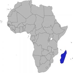
The Republic of Madagascar is about 250 miles away from Mozambique off the east coast of Africa. It is the fourth largest island in the world and is roughly the same size as California.
Madagascar has a wide assortment of minerals, rocks, and fossils because of its complicated geological history. During the Early Jurassic epoch (~200-174 million years ago), the super continent of Gondwana began to break apart. By the Early Cretaceous epoch (~100-145 million years ago), the combined landmass of Madagascar, Antarctica, and India separated from the African and South American plates. India and Antarctica would then split from Madagascar during the Late Cretaceous epoch (145-66 million years ago). India would eventually collide with Asia during the Paleogene period (66-23 million years ago), creating the Himalayan mountains.
Madagascar began landlocked and ended up as an island in the Indian Ocean. Just as South America and Africa look like two matching puzzle pieces, the eastern and western coasts of Madagascar appear to fit with Africa and India respectively. These earth changes are more easily seen in the country’s paleontological record. The separation from Africa created depressions on the western third of the island that developed into sedimentary basins over time. Sea levels were much higher during the Cretaceous and Jurassic periods and parts of Madagascar were covered by a shallow sea, like the inland Western Interior Seaway that split North America in two. Underwater sedimentation ended when the island was slowly uplifted during the separation of Madagascar and India.


